|
|
the-south-asian.com July / August 2006 |
|
|||
|
August/September Contents
Sufis
- wisdom against 50
years of mountain Heritage cities:
Cotton - the fibre of
|
|
||||
|
Page
2 of 7
50
years of Climbing – Everest, K2, & Nanga Parbat by
Salman Minhas
First published January 2004
Nanga Parbat - the killer mountain
Nanga Parbat Photos Courtesy www.concordia-expeditions.com
Early History
This much is known now
that around 500 BC, there were “rock art” hunters /gatherers in the vicinity
of Nanga Parbat, who worshipped the mountains. Their art is still visible in
some of the northern areas of Pakistan (Chilas, Skardu). According to a Lok
Virsa publication [ see reference below], the western Tibet population was
the result of the blending of at least three distinct peoples - Central
Asian Dards/Shina tribes of Gilgit, and the Mons of Northern India [
Kashmir]. The third, numerically greater to these two, are the Mongolians
who are the Tibetan Nation. Herodotus, the Greek Historian mentions the
Dards – so do Ptolemy and Pliny, the Roman historians. Later the Scythians,
Parthians [Taxila Buddhist influences– Stupa making, Brahmi & Kharoshti
script era] influenced this area. In its heyday, the Roman empire traded
vigorously [silk, cotton, muslin, paper making, china, etc] and
manufacturing techniques spread to the Middle East & Europe via the many
arms of the Silk Route with India and China. The Karakoram arm went via many
passes in Kashmir,
Ladakh and Baltistan.
The Shina Tribe people
have a dying language, Shina.
This language is spoken by related tribes living on both sides of the
"Line-of-Control" near Chilas, Gilgit and in the Gurez valley along the
Kishen Ganga River. Due to use of other [Urdu, Hindi] languages, its use has
steadily decreased. The Gurez Valley in Indian Kashmir, being isolated in
the mountains, is unique in the sense that it has preserved and protected
the culture of the Dard / Shin and their language,
"Shina".
Baltis and the Sherpas
of Nepal have migrated from various regions in Tibet. The word Sherpa means
Easterner in Tibetan. The early settlers of western Tibet were the “Mons”.
Baltistan is also known as Tibet-e-Khurd in Persian [Little Tibet]. Baltis
are actually part of the western Tibetan people. The people of Baltistan are
from mixed races - the majority coming from the Tibetan stock. The other
races found are Dardic, Central Asian Turks and Kashmiris. The language
spoken is Balti, which is an archaic form of Tibetan similar to Ladakhi
spoken in Ladakh nearby on the east. Ladakh formed part of the old Tibetan
kingdom. [See the excellent book “Baltistan & Ladakh”, - A History by
A.H.Francke – Lok Virsa, Pakistan edition 1986]. The names of Skardu
[originally Skardo] and those such as Biafo, Baltoro, ending in the letter
or sound of “O” indicate that these names were originally Tibetan. Balti
porters have achieved great climbing feats as described in the section on
Karim, the Balti Porter, by Greg Mortensen below. The
people of Hunza, the Hunzakuts, are believed to be the descendants of the
five wandering soldiers of Alexander the Great. The people of Hunza speak
Brushuski, an aboriginal language. Incidentally, the two Pakistani K2
climbers, Ashraf Aman and Nazir Sabir, are from Hunza. Various dynasties
have ruled the areas here. They are Tarkhans of Gilgit; Maglots of Nagar;
Ayash of Hunza; Burushai of Punial; Makpons of Skardu; Amachas of
Shigar; Yabgus of Khaplu. [AD 600 to AD 1800]. Hunza is also considered to
be
the “Shangri-La” from
James Hilton’s book “Lost Horizons”. The famous Hunza diet of apricots is
legendary; so too is the longevity myth of its people as documented by the
National Geographic, November 1975 – Hunza. , March 1994 –High Road to Hunza
-by Jonathan Blair
The rock
carvings and images of Buddha in the region date back to the period of Great
Tibetan Empire. When the Buddhist people of Gandhara migrated and passed
through the present northern areas of Pakistan, they settled at some places
temporarily and carved drawings of stupas, scenes of their experiences and
images of Buddha with texts in Kharoshti language. Rock carvings have been
discovered along the road between Gol and Khapulu, and Skardu and Satpara
Lake. However these rock carvings are probably similar to the ones seen near
the Indus river rocks at Chilas and belong to the Shina-Dard people. In
Skardu, the only surviving rock with Buddhist carving is located on Sadpara
road. In his book “The Gilgit Game”, John Keay [OUP, 1993], writes that somewhere
around AD 1400, Baltis started to convert to Islam.
“Before starting back down to the drowsy world of Gilgit, there is more to
be seen ……………………. Turn back from the peaks of the Karakorams, and face due
south. Here lies the true horror of the Himalayas.
This time there is no deep and distant perspective; the horizontal is
unrepresented. You are staring at a wall; it rears from the abyss at your
feet to a height for which the neck must crane back. Such is
Nanga Parbat,”the
Naked Mountain”;
its navel now confronts you. More a many peaked massif than a single
mountain, Nanga
Parbat marks the
western extremity of the Great Himalaya;
it is a buttress worthy of its role……………………… Beautiful is not an appropriate
adjective. It is too formless; there is no slender fang like that of
Rakaposhi or the
Matterhorn and
none of the grandiose harmony of Kanchenjunga
or Mount Fuji.
An uncut stone, it impresses by reason of its dimensions, not its
shape……………… [“The
Gilgit Game”: The Explorers of the
Western Himalayas
1865-95, Oxford University
Press 1979]. John
Keay]
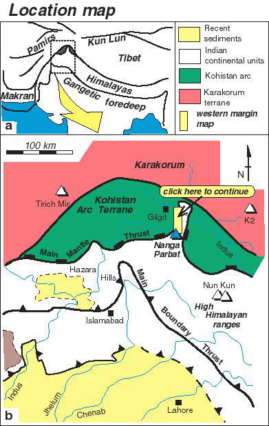
The Karakoram and the
Himalaya,
the newest mountain ranges in the world, began to form some 5 million years
ago when the Indian sub-continent drifted northwards and rammed into the
Asian landmass. By this time the dinosaurs were already extinct. India is
still racing north at the geologically supersonic rate of five centimeters
(two inches) a year and the mountains are still growing by about seven
millimeters (1/4 of an inch), annually.
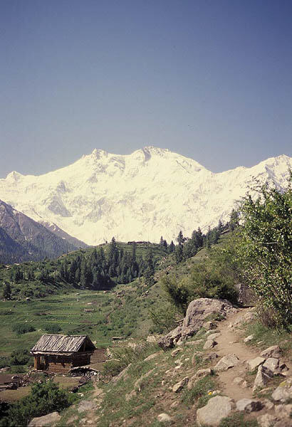
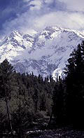
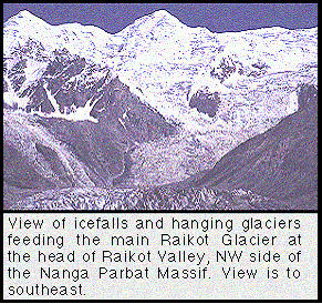
L-R: Rupal face of Nanga Parbat; icefalls and glaciers feeding the Rajkot glacier
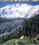
The Rupal Valley, on the south side of Nanga Parbat, is accessed via the Astor Valley, which is off the Karakoram Highway (KKH). KKH is 1,260 kilometers (900 miles) long –from Kashgar in China to Mansera in Pakistan] and is overshadowed by towering, barren mountains, a high altitude desert enjoying less than 100 millimeters (four inches) of rain a year. In many of the gorges, through which it passes, the KKH rides a shelf cut into a sheer cliff face as high as 500 meters (1,600 feet) above the river. The highway is an incredible feat of engineering and an enduring monument to the 810 Pakistanis and 82 Chinese who died forcing it through what is probably the world's most difficult and unstable terrain. The road to Nanga Parbat lies between Jaglot and Chilas. There is a bridge near Chilas where the sign to Fairy Meadows is posted; as you approach the mountain, a sign on the KKH advises you to look toward the peak of the ‘Killer Mountain’. The trek to Fairy Meadow takes about 2 days and provides spectacular views for photography, especially with a good camera, facing the Nanga Parbat north side. KKH runs through the middle of this collision belt. At Tatta Pani , after Chilas, you can see the sulphur springs along the KKH and this is considered by geologists to be the fault line. This is also where there is an earth tremor, on average, every three minutes. Hence the avalanches on these mountains, leading to climbing difficulties.
[See pictures at the
link:
http://www.lehigh.edu/~pkz0/nanga_files/Ndata.html ].
Local people will ask
you to travel fast on this section of the KKH due to land slides occurring
frequently. Also the jeep road to Fairy Meadows was apparently closed after
the recent earthquakes in 2002, so do check with the locals on this point in
case you are traveling to Fairy Meadows.
“Crumbling rock” is an
apt description for the giant, gray, snow-capped slag heaps that tower above
the gorges cut between them. Perhaps even more remarkable is that at Nanga
Parbat there is virtually no evidence of early Himalayan metamorphism. While
these rocks were clearly involved in a major collision event, recent
processes have completely obliterated any igneous or metamorphic signature
of the original collision. Some 30 years ago, a Pakistani geologist, Qasim
Jan, working with an international team on the history of Nanga Parbat,
eventually led to discoveries that have changed geological theory forever.
Nanga Parbat was revealed to be extraordinarily young, or only 1-2 million
years old. It is eroding at a spectacular rate due to glaciers, the Indus
River, and immense precipitation, yet at the same time it is growing faster
than any other mountain on Earth. More importantly, its high growth rate is
directly due to the erosion it endures. A video on this is available for
interested readers. [Nanga
Parbat: Naked Mountain:
Pakistan’s fast-growing mountain, Nanga Parbat, challenges geological
Theory. 57 minutes, Color ,Grade Level: 7-12, College, Adult , US Release
Date: 2002, Copyright Date: 2001 ; ISBN: 1-56029-954-7. Directed by Doug
Prose & Diane LaMacchia, Produced by Earth Images Foundation, Sponsored by
the National Science Foundation. ]
Mountains and Men - Introduction & Early Surveyors Nanga Parbat - the Killer Mountain K2 - the most difficult mountain to climb Women on Nanga Parbat, K2, and Mt.Everest
|
|||||
|
Copyright © 2000 - 2006 [the-south-asian.com]. Intellectual Property. All rights reserved. |
|||||